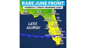
Florida Gets a Rare June Cold Front Thursday Into Friday Dropping Morning Lows to the 60s Statewide With Lower Humidity Relief
Posted on
0
Weather
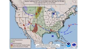
North Dakota, South Dakota and Nebraska Face Severe Thunderstorms and Flash Flooding Tuesday as Northern Plains Pattern Turns Active June 2
Posted on
0
Weather
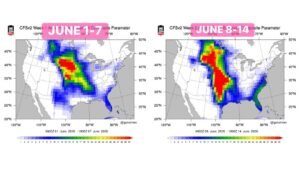
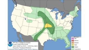
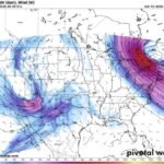
Kansas, Nebraska, Oklahoma and Texas Face Explosive Supercell and Tornado Potential as Major Pattern Shift Ignites the Plains June 1 Through June 14
Posted on
0
Weather
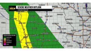
Iowa and Nebraska Border Communities Including Sioux City Face Level 2 Slight Risk Tonight With Isolated Tornado, Large Hail and Damaging Winds Possible
Posted on
0
Weather
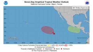
Eastern Pacific Tropical Development Reaches 90 Percent Chance as Second Area of Interest Emerges Off Southern Mexico Coast on May 31
Posted on
0
Weather
Alabama Including Birmingham and Huntsville Faces First Alert Weather Day Monday as Organized Storm Line Brings Damaging Winds, Hail and Intense Lightning by 2 PM
Posted on
0
Weather
Johnson County Kansas and Kansas City Hit by Fast-Growing Thunderstorm Bringing Very Large Hail and Damaging Winds Over the Next 5 Hours
Posted on
0
Weather
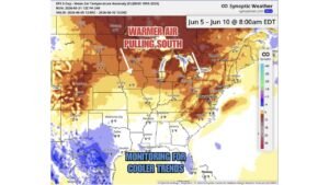
Minnesota, Michigan, Colorado and Washington D.C. Warm Up 4 to 11 Degrees Above Normal June 5 to 10 While Texas, Louisiana and Florida Hold Near Average
Posted on
0
Weather
Missouri and Illinois Face Level 2 Slight Risk for Damaging Winds and Large Hail After 6 PM Sunday as SPC Outlook Covers Central Plains to Deep South
Posted on
0
Weather
Rapid City, Ainsworth and Alliance Named Most Likely Spots in the USA for Large Hail and Damaging Winds as Level 2 Storms Build Saturday Afternoon
Posted on
0
Weather
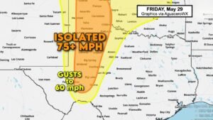
West Texas Including Midland, Amarillo and Lubbock Face Isolated 75 MPH Dry Downburst Threat Under Level 2 Slight Risk Friday May 29
Posted on
Weather
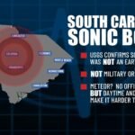
Columbia, South Carolina Sonic Boom Source Remains Mystery as Earthquake, Military and Aircraft Causes Ruled Out With Meteor Theory Gaining Ground
Posted on
0
Weather
Southern Kansas and Oklahoma Face Conditional Supercell Risk Friday Afternoon as Dryline, Near 3000 CAPE and High Clouds Create Uncertain Setup
Posted on
0
Weather
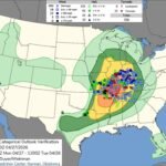
Illinois, Indiana, Missouri and Kentucky April 27 Moderate Risk Event Produces 25 Tornadoes but Underperforms as Warm Sector Supercells Fail to Sustain
Posted on
0
Weather
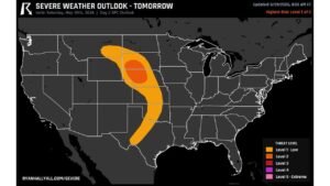
Nebraska and South Dakota Carry Highest Tornado Risk Saturday as Severe Weather Threat Spans Texas to Montana on May 30
Posted on
0
Weather
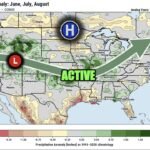
Texas, Kansas, Missouri, Tennessee and Ohio Valley Face Wetter Than Normal Summer as Strong El Nino Pattern Sets Up Active Jet Stream Through June, July and August
Posted on
0
Weather
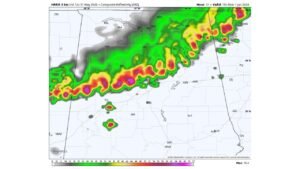
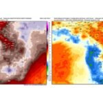
Florida Rainfall Forecast Drops Sharply From 6 to 7 Inches Down to 1 to 2 Inches as Latest Model Run Shows Major Trend Reversal Through June 8
Posted on
0
Weather
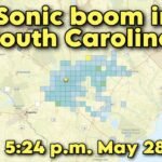
Columbia, South Carolina Rocked by Massive Sonic Boom at 5:24 PM on May 28 as USGS Confirms No Earthquake
Posted on
0
Weather
Kansas and Oklahoma Targeted for Significant Severe Weather Saturday as Powerful Upper Trough Charges In From the West
Posted on
0
Weather
South Central Kansas Including Wichita, Hutchinson and Newton Under Special Weather Statement for Funnel Clouds and Landspouts This Afternoon
Posted on
0
Weather
Illinois, Kentucky and Tennessee Split by Invisible Weather Line Friday Night as Storms Push South While Great Lakes High Pressure Holds the North Dry
Posted on
0
Weather
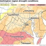
Washington D.C. and Virginia Close Out 10-Day Rain Streak With Drought Still Gripping the Region as May Ends Drier Than Normal
Posted on
0
Weather
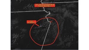
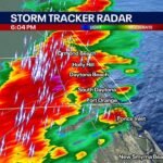
Daytona Beach, Florida Slammed by Blinding Rain, 50 MPH Gusts and Lightning as Rainy Season Opens With a Punch at 6 PM